

📍 Location & Significance
The barrage spans the Indus River about 16 km northwest of Kot Addu and 20 km southeast of Taunsa Sharif.
Constructed between 1952 and 1958, it serves vital roles in irrigation, flood control, and as a multi-utility crossing for roads, railways, pipelines, and power lines .
With gates that can discharge up to 1 million cusecs, it’s a critical water-regulation structure .
🌾 Irrigation & Agriculture
Feeds over 2.35 million acres (950,000 hectares) of farmland across Muzaffargarh, D.G. Khan, and Panjnad canal systems .
Supports key crops including cotton, sugarcane, wheat, and fodder, sustaining livelihoods across southern Punjab.
🐾 Ecological & Environmental Role
Declared a wildlife sanctuary in 1974, and designated a Ramsar Wetland of International Importance in 1996 due to its rich biodiversity .
Habitat for endangered species such as the Indus River dolphin, hog deer, various fish, waterfowl (ducks, cranes), reptiles, otters, and aquatic plants .
In 2015, the government and WWF-Pakistan launched a Rs 110 million management plan to conserve habitat and promote eco-tourism .
🛠️ Infrastructure & Rehabilitation
The barrage features 65 gate bays over a 4,346 ft (1,325 m) span .
In 2003, the World Bank funded a $123 million rehabilitation project, addressing ageing infrastructure and structural erosion .
Ongoing modernization aims to strengthen embankments, install remote-controlled gates, and improve safety systems.
⚠️ Flood Control & Challenges
The barrage plays a key role in flood management but has been criticized after the 2010 floods, with some blaming insufficient height and erosion measures .
It’s considered a high-priority project for rehabilitation to ensure food and water security for millions in the command area .
🌐 Multiple Uses
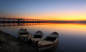
Road & rail bridge: Key connector for vehicular and train traffic across the Indus near Kot Addu.
Utility crossing: Supports gas, oil pipelines, telephone lines, and high-voltage electricity transmission .
🚧 Local Impact & Future Prospects
Irrigation lifeline: Kot Addu’s farmers rely heavily on the water distributed via barrage-fed canals for crops like wheat, cotton, and sugarcane. Any failure or breach could directly threaten agricultural productivity and livelihoods.
Eco-tourism & recreation potential: Plans are in place to develop a 20-acre recreational park along its banks—complete with parking, camping, boat safari, fishing, and perhaps a historic “Indus Queen” riverboat exhibit.